MEXICO
PART 3 – CHICHEN ITZA


The sun generously scattered its rays awakening us in one of the most beautiful places in the world – the sunny Caribbean resort of Playa del Carmen in charming Mexico. We got up with a smile that didn’t come off our faces all day long, visiting some of the most famous ancient Mayan cities.
It was not known exactly where and when the Mayans had come to these lands, but their calendar began to count the days of August 11, 3114 BC. Archaeologists divided Mayan history into three periods: The first period was preclassical, spanning the time before Christ to A.D. 250. During this period, among the Mayans, who surveyed corn and lived in small communities, came the Olmecs, who had their own script, calendar and cult of the jaguar. The Olmecs built more priestly and ceremonial centers than cities. It is no coincidence that the culture of the Olmecs was called the mother of Mexican culture. Around the middle of the first millennium BC, the Olmec civilization disappeared, and the reasons for this remained unclear. Mayan culture, however, began to develop. In this respect the population of Mexico was not so ancient as that of Mesopotamia and Egypt. The Mayans lived in what is now Mexico, Guatemala, and Belize, as well as parts of Honduraz and El Savlador.
After 250 years, the Mayans already had a formed culture and began the classical period, which lasted until 950 AD. From this period remained the best architectural and scientific achievements, ceramic objects, etc. Art was at its peak, as were sciences such as astronomy, mathematics, writing and the emergence of the Mayan calendar. The population grew and important centers with temples were formed, as well as pyramids, palaces and sports fields. At that time, cities such as Copán and Palenque flourished, but the most influential city was Tikal, the largest city in precolonial America.
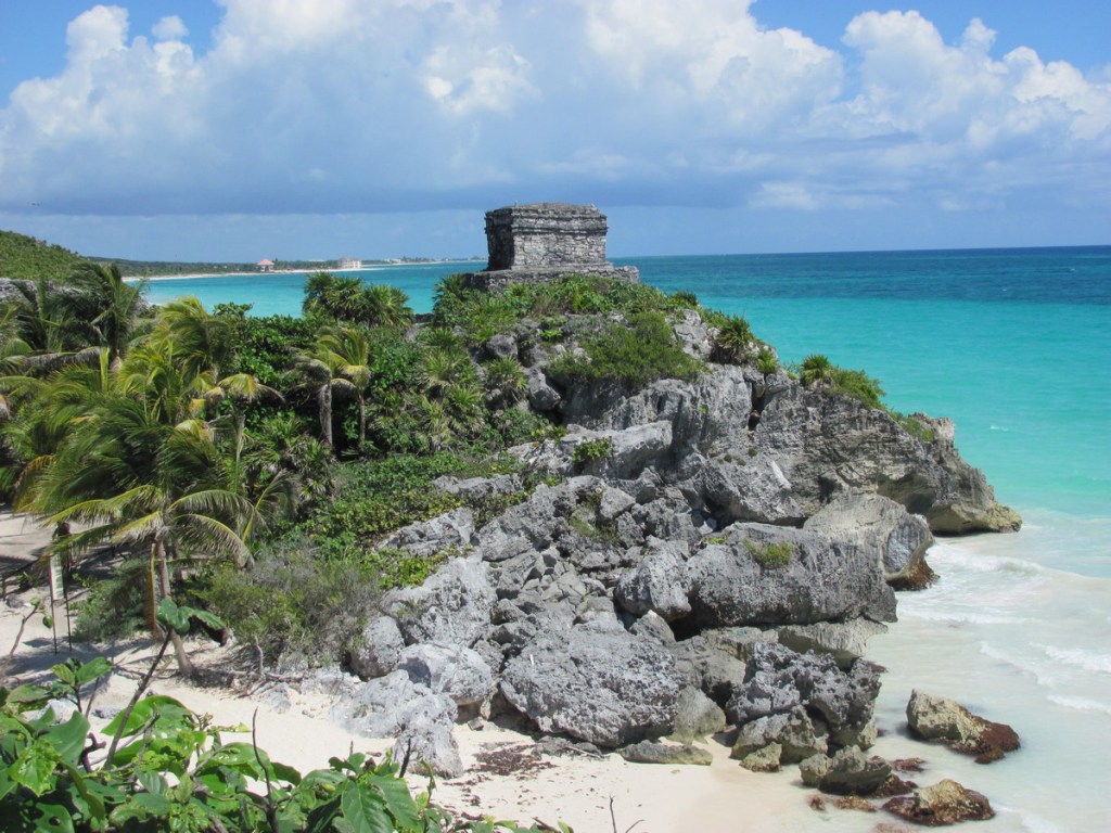
The third period was post-classical. From this period there were some majestic pyramids such as Tulum and others near Cancún. It was at this time that we passed near Tulum, where on the left side of the bus we saw a pyramid, part of the large complex. Tulum was called by the Spanish El Castillo / castle and was a wonderful combination of ancient architecture and sea, but according to our tour guide, in terms of ruins, the same were not as magnificent as Chichen Itza, for example, nor did they have as many hieroglyphics and images as Palenque. The name Tulum meant a wall, a fence in the Mayan language. The first name of the city, however, was Zama, meaning the City of Sunrise, because it overlooked the rising sun.
Along the way, the guide also told us about the many Mayan gods, among which the sun god occupied a central place. The Mayans had 5 different symbols to represent the sun. One of these symbols, for example, represented both day and sun. Another image of the sun was a human face—that of a young man and an old man. The young man symbolized the sunrise, and the face of the elderly man – the sunset.
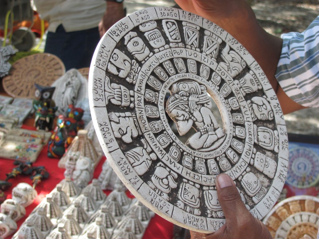
According to archaeologists, only the Mayans and Egyptians had a separate solar calendar. The Mayan one consisted of 365 days – accurate almost like the current we have today. The Mayan calendar, however, counted down not the years, but the days, saying that a person is so many days old, not years, like now. I liked this idea, despite the large numbers. Nowadays the understanding “34 years old” was too general, and with the Mayans, the age changed every day, and one appreciated the meaning and utilization of each day, and did not wait the passing of another year.
In the Mayan language, the period of 360 days was called “tum”. It was divided into 18 months of 20 days. Separately, they added a short month of 5 days. Very interesting and again accurate, the Mayans wrote the numbers. To write all the numbers they needed only three symbols: a dot, a dash and a mussel. One point meant one, two points – a pair, three points – three, four points – four. Five, however, was not written with five points, but with one long bar. So six was a lower line and one point, seven was a lower line and two points, and so on. Nineteen was three bars and four points. The other symbol was on the zero, written with a shellfish. The mussel meant nothing. The Mayans understood the importance of zero and used it much earlier than the Hindus and Arabs, who subsequently introduced it to Europe.
The Mayans also had another sacred calendar consisting of 260 days, which had nothing to do with the sun, planets or moon. It consisted of 13 months, each with 20 days. This calendar was more related to religious rituals, and shamans calculated the season for crops and the beginning of religious ceremonies. According to this calendar, they also made various predictions. Each day of this calendar was dedicated to a different god who determined the fate of people born on his day. Later I learned that, according to my birth date, my patron was the god of the Reed (Ben), who made people on that day inquisitive – lovers of learning new things and travelers, something I found easy to believe.
Subsequently, the Mayans were able to combine the two calendars, creating two circles – one large and in it a smaller one, which rotated in a specific order, so that each day of one calendar corresponded to the day of the other.
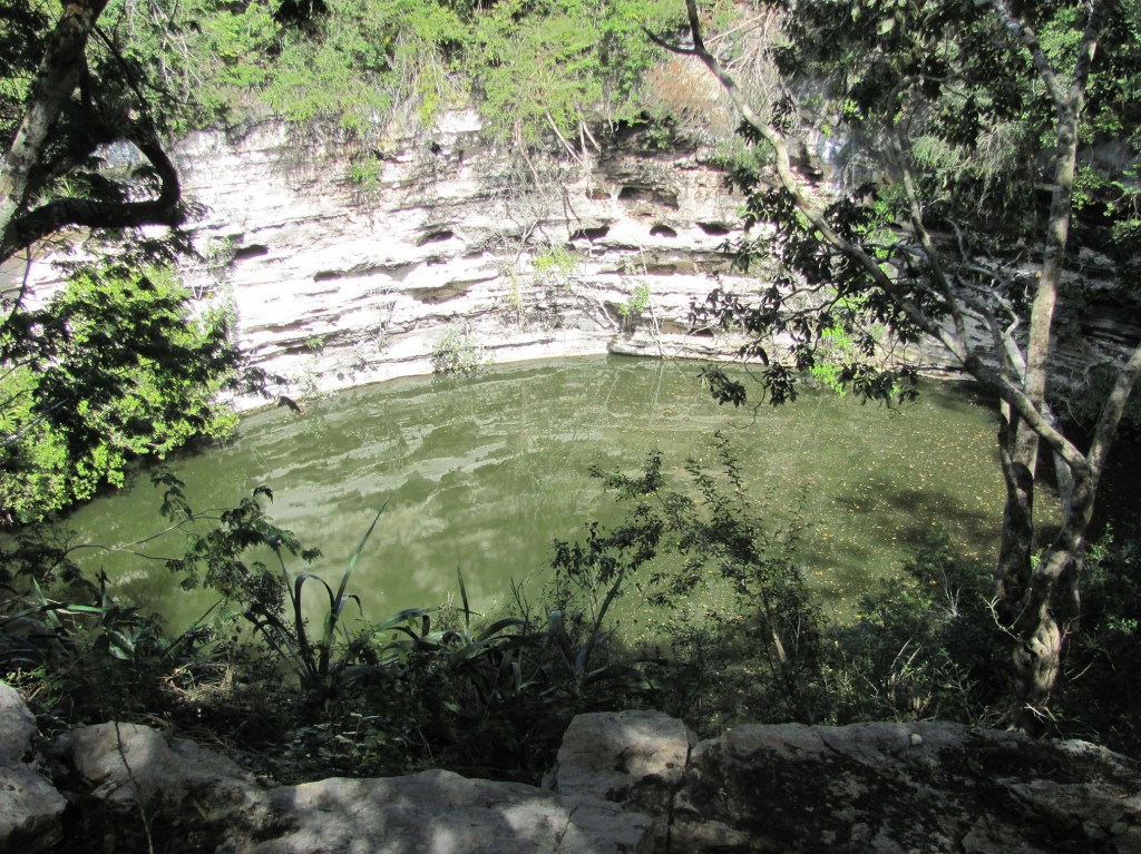
Along the way, we passed by and learned more underground caves filled with water called cenotes. Currently, there were over 8,000 cenotes in Mexico. Some of them are with drinking water and others with contaminated water. It was such a cinote with contaminated water that we saw in Chichen Itza. There were 5 wells in the ancient city, of which 4 were with drinking water and 1 with contaminated water. However, it was the most sacred for the Mayans and we visited it. There were many rituals for the god of rain, as sacrifices were given to him children and young people, and less often elderly one. Such sacrifices were given because of the great drought that reigned there. Drought was particularly dangerous for corn plantations. That is why the Mayans considered sacred those springs that provided them with water in dry periods. In this cenote of Chichen itza were found not only many skeletons in the water, but also jewelry and valuables of amber, gold and silver, corals from the Caribbean bay, etc. These findings could be seen today in the museum in Mexico City. Another part could be seen at Harvard University, where they were brought by archaeologist Edward Thomson.


The tour guide was speaking so fascinatingly that we didn’t feel when the time and the road passed. The first stop of our bus was at a gas station where we took a short break. Then we continued to Chichen Itza, passing through a town where almost every house was hung hammock, and somewhere more. There were many nice houses, but the poor with thatched roofs prevailed. In several places along the way, we reduced our speed completely and passed by police patrols. It turned out that when entering and leaving all major cities there were such guards, and unlike the Bulgarian traffic police, these were armed with assault rifles and recorded the numbers of all cars.
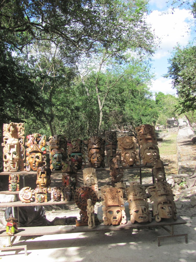
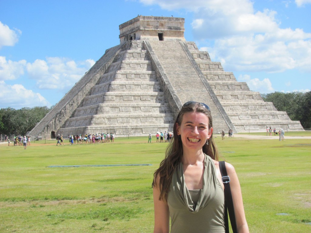
The first thing we saw passing through the entrance to the ancient Mayan city of Chichen Itzá were the many peddlers selling masks and other traditional souvenirs. After passing them we found ourselves in front of the highest Mayan pyramid. It was majestic, peculiar against the background of the crystal blue sky above it and the few fluffy clouds for decoration. The base of the pyramid was square, with the height of the sides rising 24 meters in stages to 9 levels. Here we learned that the pyramids played an important role in the Mayan cities. Unlike the Egyptians, they did not use the same for tombs. The pyramids had many other uses, including a place for rituals, for orienting directions (where is the north, south, east and west), as well as for a calendar. To the top of the pyramid there were 91 steps that represented the days of the year. Multiplied by the four walls becomes 364 plus the platform on top 365 days. If the pyramid was viewed from only one side, then the angles in it were 18 or this was exactly the number of months according to the solar Mayan calendar. A particularly interesting phenomenon occurred on this pyramid during the spring and autumn equinoxes (March 21 and September). Then the light so lit up the pyramid that there was a shadow on its corners, resembling a huge snake descending upon them. They didn’t achieved accidentally this effect and what a pity that modern construction is not so precise, meaningful and accurate as the Mayan one.
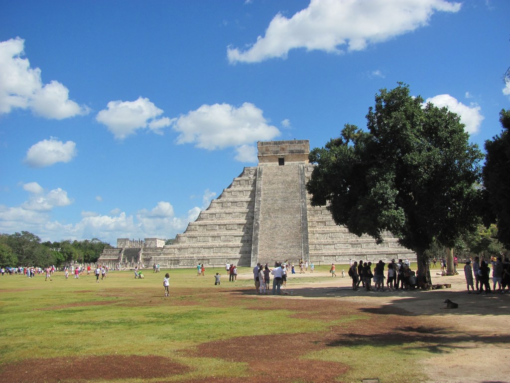


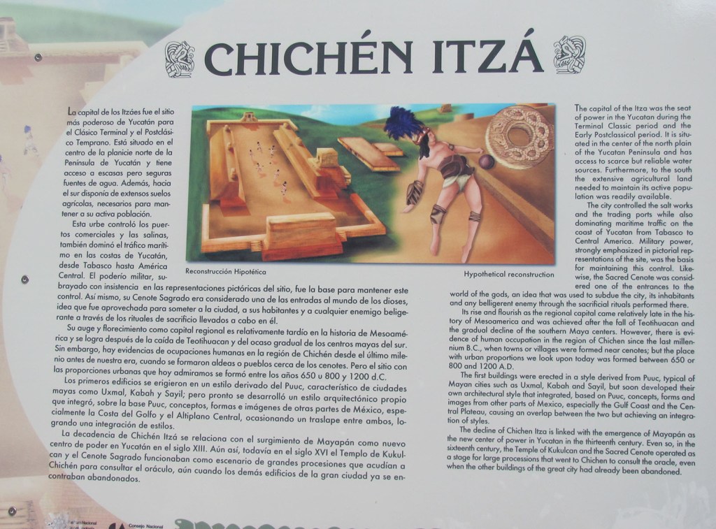
This pyramid was also called El Castillo. The very name of the city Chichen Itza meant “the mouth of the well of Itzas” – itzas were the tribe that lived here. The first buildings on this site date back to 435 AD, with the settlement growing between 600-900 AD. The Itza tribe itself arrived in 900 and reigned until 1200. Then at the beginning of the 15th century the settlement was abandoned for an unclear reason. A century later, the Spaniards came, leaving only a beautiful legend from the city.
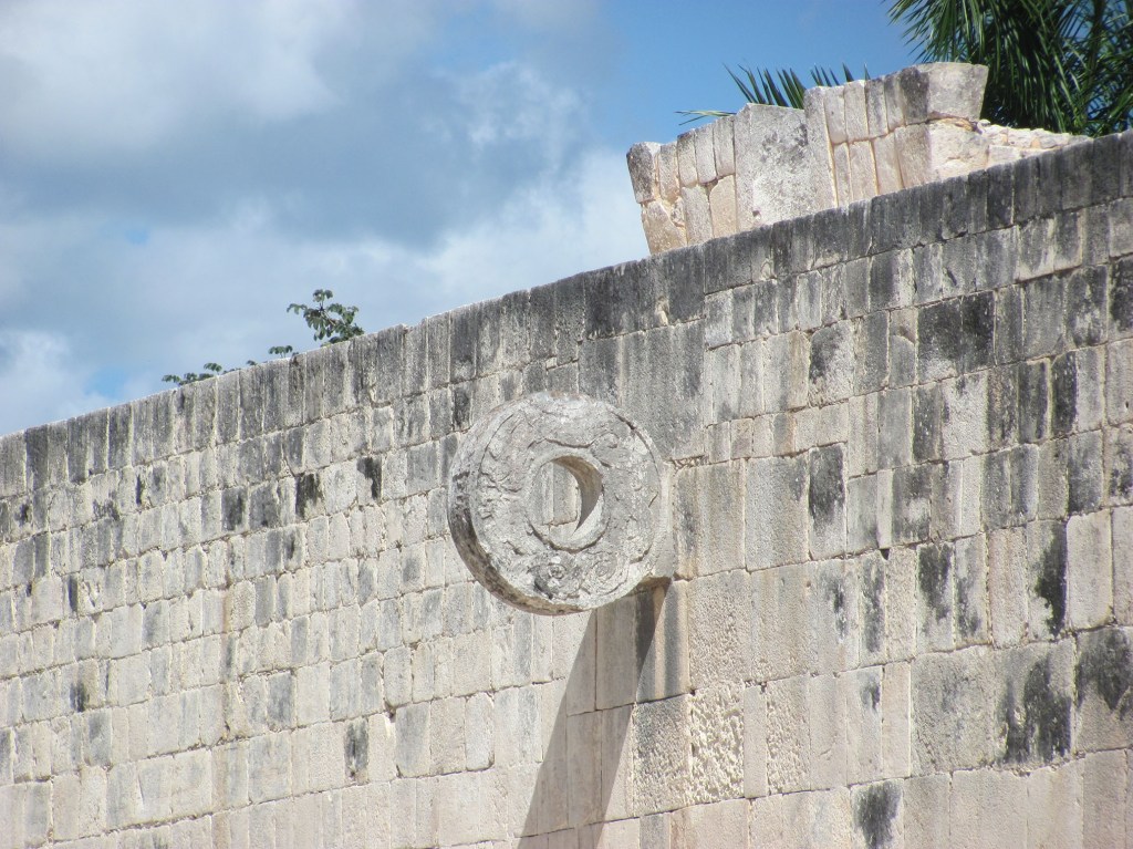
After the majestic pyramid we headed to the playground, and it turned out that in most Mayan settlements there were such stadiums. The course we passed through was 146 meters long and 36 meters wide. From the two longitudinal walls there were beautifully painted walls and decorated a ring through which the Mayans had to pierce the ball without touching it with their hands – a kind of mixture of today’s football and basketball. However, the game was much more difficult, as the ancient rubber balls found weighed more than 2 kg.
The eastern wall of the Mayan city was part of a tall building now called the Jaguar’s Temple. On the other side of this temple was a long wall, with many figures on it, each of them depicting reliefs of human skulls. They were over 500. The wall was called Tzompantli meaning “wall of skulls” and most likely served as a cult of the dead. There were no two faces alike, and I wondered if there were any real human remains behind these stone slabs.
There was no time to wonder, the tour guide went fast forward, trying to show us maximum things in the short time we were there (somewhere around 3 hours). We passed through the temple of Venus, and it turned out that for the Mayans it was not the Goddess of Love, but the God of War. It was located only 100 meters north of the great pyramid and was quite well preserved with steps at the end of which protruded dragon or jaguar’s heads. In fact, Venus was considered the twin brother of the sun, and the star was the last we see in the morning (as she helped her brother get up to the sky) and the first at night to take her brother to sleep.


We also passed through the “thousands of columns” that were once part of the Temple of Warriors. Here there were remaining images of warriors, eagles and jaguars feeding on human hearts. You can’t say that the Mayans weren’t hearty people! It was their beating hearts that sacrificed to the gods, and they were taken out of the chest of the chosen ones—usually the smartest and most beautiful people. The saying “to have a flaw is against the evil eye” made sense.
Part of the columns turned out to be ruins of the market, and behind them it is believed that the residential buildings were. We headed to the sacred well / sinote, then stopped in front of the impressive El Caracol or Mayan astronomy, located just below the constellation Orion. Then followed a new majestic temple, baptized and used by the Spaniards as a Church. The building of the “church” was rich in ornaments on the walls. The facade was great for photography, we just didn’t have time for contemplation. Otherwise, we learned that the building was an excellent example of Mayo-Toltean culture – similar to the Greco-Roman culture in Europe. Just as the Greeks influenced Europe, the Japanese in Asia, so the Mayans influenced the local culture.
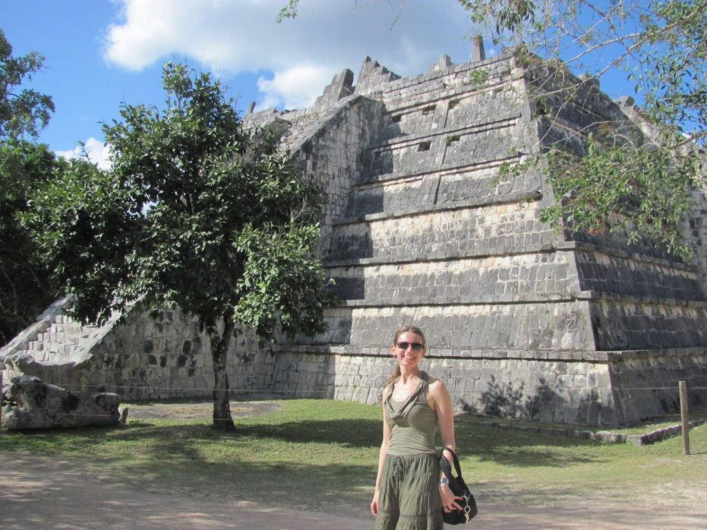
We passed another pyramid, smaller in size, but resembling the great pyramid. This one was called “the grave of the great priest” and also consisted of 9 levels. The interesting thing here was that under this pyramid archaeologists had discovered a tunnel 20 km long leading to another Mayan city. According to the rituals described, this tunnel had led the dead to heaven or the underworld.
Here we saw the first larger iguana, which we subsequently saw a lot in Mexico, especially among the ruins. I named them “the guardians of the ancient cities” and the last living inhabitants of the abandoned Mayan cities.


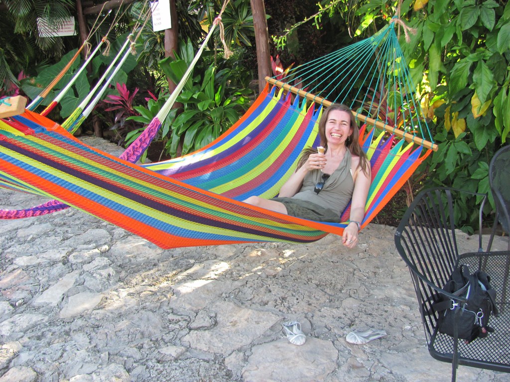
We also had to abandon this wonderful place, getting back on the bus and heading to the city of Mérida, which was 120 km from Chichen Itza. Before that, however, at 15:00 we stopped at a roadside picturesque restaurant with thatched roofs named Pueblo Maya. Eating a buffet with a cold drink cost us $25 per person. The food was not cheap, but I liked the restaurant with its beautiful gardens, where there were also trees with numerous bananas, as well as colorful comfortable hammocks, for a light nap after the hearty food.
At 5:00 p.m. we left the restaurant, with the sun rapidly falling over us, and just fed, we quickly began to feel sleepy. I still didn’t feel like I was on the other side of the world. People were so kind that I felt at home.


GENERAL INFORMATION ABOUT MEXICO:
Location: Mexico (United Mexican States) are located in North America, bordering the United States to the north, Guatemala and Belize to the southeast, the Pacific Ocean to the west, and the Gulf of Mexico and the Caribbean Sea to the east.
Capital: Mexico City
Area: 1 972 550 sq.km
Population: 121 736 809 people
Official language: Spanish
Climate: tropical climate
Time zone: UTC-8 to -5
Currency: Mexican peso (MXN)
Additional information: http://www.chichenitza.com/

TRIP TIPS FOR CHICHEN ITZA:
Best time to visit: all year round, with probably December to April being the best months for beach and sightseeing. If you want to see the commination of Chichen Itza, you should come during the spring and autumn equinox (around March 21 and September 21), when the light descends like a snake on the main pyramid.
Typical foods and drinks worth trying: Besides the famous Mexican tacos and boritos, the Yucatan Peninsula offers numerous specialties with seafood, avocados, oranges and chicken.
How to get to Chichen Itza: Chichen itza is located on the Yucatan Peninsula and is the largest archaeological city of the pre-Colombian Mayan civilization. The easiest way to get here is by day trips from Cancun, Playa del Carmen or Merida, but if you decide you can go by car yourself.
